🌄🔍💀 Big Lake Distract California Whea’ Farms Was Dey Wen Stand One Year Ago 🌊🌾
Da Tulare Lake wen come back afta da intense storms wen pound da state dis winter, an’ da buggah goin’ stick around in da Central Valley fo’ months — an’ maybe even years. 🌧️❄️🏞️
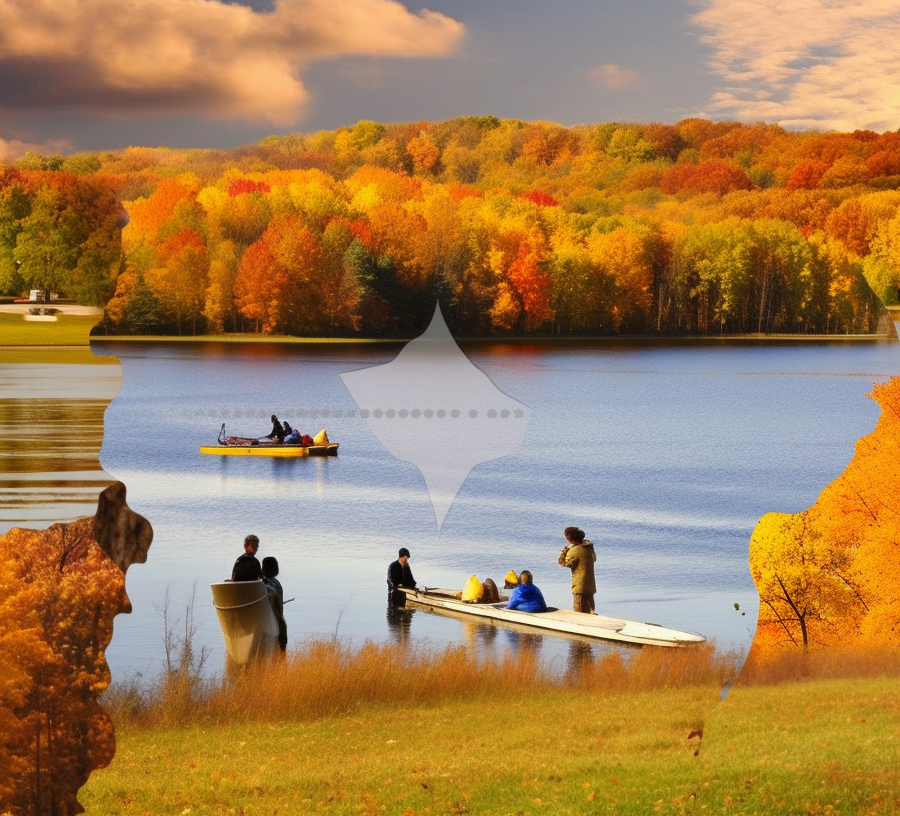
Dis ting sound like da ocean an’ almost as big as Lake Tahoe. Da waves gettin’ pushed by da wind stay soft an’ warm, surpisingly. Tulare Lake look like stay goin’ on an’ on on top of dis huge brown an’ green flat land wea’ da Central Valley stay, glimmerin’ like one unreal blue vision. 🌊💙🌴
Three months done pass since dis lake, wea’ been around since Ice Age, wen come back up from da basin wea’ used to hold da biggest freshwater body west of da Mississippi River. Da buggah been all dried up by humans, but every so often, it wen try fo’ make one comeback. But dis time, afta da winter storms, da force wen come back strong. 💧❄️
First, just little bit watah, den all of sudden, da flood come rushin’ in. Da watah wen swallow one big chunk of da country’s best an’ most valuable farmland in da blink of an eye. Like as if you can grow one tomato dat fast. Thirty square miles, den 50. Den 100. Den more. 🌊🍅
Right now, as summer startin’, Tulare Lake stay ’bout 168 square miles, trap up by thousands of acres of clay soil an’ da fact dat no can find one natural outlet. Dis buggah so huge, you gotta look at ’em wit’ satellite fo’ track ’em. Dis whole ting wen start from heavy rains amplified by climate change ova da mountains wea’ da rivers flow from da Sierra Nevada. Da snowpack wen pile up so much, almost set one record. So now, da snowmelt keep feedin’ da lake. 🌨️❄️🏞️
You goin’ see detours an’ roadblocks all ova da place by da lake. Da watah stay gettin’ polluted wit’ chemicals, manure, an’ diesel. Palm trees an’ power poles stickin’ out from da surface. Daytime, get dragonflies all ova da place. Evenin’ time, get mosquitoes buzzin’ around. Plenny birds movin’ in too — swallows, wrens, ducks, egrets, an’ even red-winged blackbirds. 🦆🌿🐟
Da waves carry algae on top, while underneath, da tomato an’ cotton fields, dey get abandoned cars rustin’ away an’ catfish lurkin’. 🌊🚗🐟
Jeffrey Coughlin, one airboat pilot, wen say one ting he neva see anytin’ like dis before. On one recent weekday, he wen steer his bayou-style boat through da debris-filled watah, an’ he wen talk ’bout all da devastation affectin’ da people, farms, an’ homes. Dis one real tragedy. 🛶😢
Da state’s water engineers wen try every trick in da book fo’ save as much watah as dey can an’ redirect ’em someplace else. Dey wen figure da lake’s growth stay maxed out already. But dis phenomenon dat stay around, goin’ be one major long-term guest in da farm country of California. Mr. Coughlin, who normally work in da San Francisco Bay ’bout 230 miles northwest, stay shuttlin’ crews from da Pacific Gas an’ Electric Co. Dey stay workin’ hard fo’ take out all da sunken electrical transformers from da lake bed. Wen he go out on one recent day, he had one member from da Kings County Sheriff’s Office wit’ him. Cuz of Tulare Lake, da Sheriff’s Office stay even buy one airboat fo’ demselves. 🚤🛠️
Sgt. Nate Ferrier, one of da members, wen marvel at how big dis lake stay. He neva really wen go far from da shoreline, like most people in da area. He stay spendin’ his time tellin’ da public fo’ stay away from da lake an’ follow da “No Enter” signs. Most people stay listen, but no can lie, stay hard. Dis Tulare Lake stay one big hazard an’ economic disaster fo’ plenny farmers. But in some ways, Sgt. Ferrier admit, da buggah kinda cool too. 🏞️😎
Nowadays, people stay takin’ selfies by Tulare Lake. You goin’ see couples watchin’ da sun set, daredevils wadin’ into da toxic watah. Some people even try drive through ’em, end up havin’ fo’ swim back to land or get rescued. Not too long ago, two journalists even wen kayak ‘cross da lake from Bakersfield to da San Francisco Bay. 📸🛶🌅
Right now, we still get ’bout 2.5 million acre-feet of snow water stayin’ frozen, waitin’ fo’ melt. Da Kern, Tule, Kaweah, an’ Kings rivers, dey feed da basin, so da size of da lake goin’ depend on how fast da snowmelt come down an’ how much get channeled someplace else. Watah already stay gettin’ captured by reservoirs before it even reach da lake bed. Some get used fo’ irrigate farms an’ orchards. Some get moved to places wea’ can soak into da ground an’ replenish da groundwater, which wen get depleted from drought an’ excessive pumpin’ in da past years. Some even evaporate. 💦☀️🌿
Fo’ da first time since 2006, tens of thousands of acre feet of watah from da Kern River stay gettin’ diverted through one canal to da California Aqueduct fo’ help out wit’ da water supply fo’ Los Angeles an’ odda cities. 💦🏞️🌆
Da good news, da Tulare Lake area no get plenny people stayin’ dea. Most of da land stay agricultural an’ owned by big farming companies. Da biggest community in da immediate basin, Corcoran, wen work wit’ county, state, an’ federal agencies fo’ strengthen da levees ’round da area an’ protect da ’bout 22,500 people stayin’ dea. Back in May, state officials wen say Corcoran an’ two smalla communities, Allensworth an’ Alpaugh, look like dey outta da danger zone. 🚧👥💪
But now come da hard part: History an’ science tell us dis lake goin’ take ’bout two years, an’ maybe even longer, fo’ go back down completely. Da current efforts stay helpin’, but meteorologists wen say we might get one wet winter again. ⏰🌧️❄️
Greg Gatzka, da city manager of Corcoran, wen say da big farms in da area, dey been able fo’ avoid layin’ off plenny workers by givin’ ’em jobs in less affected parts of da operations. An’ da local schools wen offer remote learnin’ fo’ da few students whose families had fo’ move. 📚👩🏫🌾
He wen mention how da local economy wen diversify afta 1983, when da lake made one big comeback. Da job loss an’ decrease in population actually helped spur da construction of California State Prison, Corcoran, which opened in 1988. 🏢👥⚖️
But no everytin’ been smooth sailin’: Dey been havin’ disputes ’bout which lands get flooded first an’ whether some farms put their own financial interests ahead of da safety of da community. Some people even havin’ second thoughts, wonderin’ if da damage could’ve been less if da big landowners wen cooperate wit’ da state an’ local governments fo’ control da floods. But authorities say da situation startin’ fo’ turn aroun’: Tulare Lake stay now officially one big prehistoric lake dat come back from da chaos dat unleashed it. 🏞️🔀🌊
“It stay goin’ be one long-term event,” Brian Ferguson, one spokesperson fo’ da Governor’s Office of Emergency Services, wen say. “Da stuff you see dea, goin’ be part of life fo’ plenty time.”
NOW IN ENGLISH
🌄🔍💀 Big Lake Distracts California Where Farms Stood a Year Ago 🌊🌾
Tulare Lake has re-emerged following intense storms that battered the state this winter, and it is expected to remain in California’s Central Valley for several months, and possibly even years. 🌧️❄️🏞️
This body of water resembles the ocean and is nearly as large as Lake Tahoe. The wind-driven waves are surprisingly gentle and warm. Tulare Lake appears to stretch endlessly across the vast brown and green plains of California’s Central Valley, glistening like a mesmerizing blue mirage. 🌊💙🌴
It has been three months since this lake, which dates back to the Ice Age, resurfaced in the basin that was once home to the largest freshwater body west of the Mississippi River. Previously drained by humans, it has made occasional attempts at a comeback, but none as forceful as what we witnessed after this winter’s storms. 💧❄️
Starting as a mere trickle, the water rapidly inundated the lake bed over a span of just a few months, swallowing up one of the nation’s most extensive and valuable stretches of farmland in the blink of an eye. It happened as quickly as it takes for a tomato to grow. Thirty square miles turned into 50, then 100, and even more. 🌊🍅
At the onset of summer, Tulare Lake now covers approximately 168 square miles. It is trapped by thousands of acres of clay soil and lacks a natural outlet. The lake has become so vast that tracking it is best done through satellite imagery. Its initial formation was triggered by heavy rainfall, amplified by climate change, over the river systems flowing through the Sierra Nevada mountains. The melting snowpack, which accumulated to near-record levels, continues to feed the lake. 🌨️❄️🏞️
The lake’s shores are lined with detours and roadblocks. Chemicals, manure, and diesel pollutants have contaminated its waters. Palm trees and power poles protrude from its surface. Dragonflies flutter about during the day, while mosquitoes emerge at dusk. The area is now inhabited by various bird species, including swallows, wrens, ducks, egrets, and chattering red-winged blackbirds. 🦆🌿🐟
Algae floats on the lake’s waves, concealing abandoned cars and catfish lurking beneath the tomato and cotton fields that dominate the lakebed. 🌊🚗🐟
“I have never witnessed anything of this magnitude,” exclaimed Jeffrey Coughlin, an airboat pilot, as he skillfully navigated his bayou-style craft through the debris-laden waters. “The devastation has had a profound impact on the lives of many people, farms, and homes.” The State water engineers have employed various strategies from California’s extensive playbook to preserve as much water as possible and redirect it elsewhere. Models indicate that the lake’s expansion has likely reached its limit. 🛶😢
However, the phenomenon that remains promises to be a long-term challenge for California’s farming communities. Mr. Coughlin, who typically operates in the San Francisco Bay, situated about 230 miles northwest, is now ferrying crews from the Pacific Gas and Electric Co. Their arduous task involves removing sunken electrical transformers from the lakebed. Joining him on a recent day was a member of the Kings County Sheriff’s Office, which, due to the resurrection of Tulare Lake, has acquired its own airboat. 🚤🛠️
Sergeant Nate Ferrier, one of the officers, marveled at the enormity of the lake. Like most locals in the region, he had yet to venture far from the shoreline. Over the past few months, law enforcement has been urging the public to stay away from the lake and respect the “Do Not Enter” warnings. Sergeant Ferrier acknowledged that most people have complied, but it hasn’t been easy. Tulare Lake has proven to be a hazard and an economic catastrophe for many farmers. Nevertheless, he added, it is also undeniably fascinating. 🏞️😎
Taking selfies by Tulare Lake has become a popular trend. Couples gather to watch the sunset, while adventurous individuals wade into the toxic waters. Some even attempt to drive through it, only to find themselves swimming back to shore or requiring rescue. Recently, two journalists kayaked across the lake in an attempt to paddle their way from Bakersfield to the San Francisco Bay. 📸🛶🌅
Approximately 2.5 million acre-feet of snow water remain frozen, awaiting the thaw. This water will eventually melt and flow into the Kern, Tule, Kaweah, and Kings rivers, which supply the basin. The size of the lake will depend on the rate of snowmelt and the capacity for diversion elsewhere. Reservoirs are already capturing water before it reaches the lakebed. Some of it is being diverted for irrigation purposes, while other portions are directed to areas where it can seep into the ground, gradually replenishing the groundwater that has been depleted by drought and excessive pumping in recent years. Some of the water simply evaporates. 💦☀️🌿
For the first time since 2006, tens of thousands of acre-feet of water from the Kern River are being diverted through a canal to the California Aqueduct, bolstering the water supply for Los Angeles and other cities. 💦🏞️🌆
Thankfully, the Tulare Lake area is not densely populated. Most of the land within the lakebed belongs to large farming operations. Corcoran, the largest community in the immediate basin, has collaborated with county, state, and federal agencies to fortify the surrounding levees, safeguarding its population of approximately 22,500 residents. State officials stated in late May that Corcoran, along with the smaller communities of Allensworth and Alpaugh, appeared to be out of harm’s way. 🚧👥💪
Now comes the challenging part: based on historical and scientific data, it is estimated that it will take around two years, possibly longer, for the lake to fully recede. Although the current mitigation efforts have been effective, meteorologists warn that the upcoming winter could bring more precipitation. ⏰🌧️❄️
Greg Gatzka, the city manager of Corcoran, indicated that the large farms in the area have managed to avoid significant layoffs by offering alternative work opportunities within less affected sectors of their operations. Local schools have implemented remote learning for the few students whose families had to relocate. 📚👩🏫🌾
Since its major reappearance in 1983, the local economy has diversified. The setbacks in employment and population during that period prompted the construction of California State Prison, Corcoran, which opened its doors in 1988. 🏢👥⚖️
However, certain issues remain unresolved. Disputes have arisen regarding the order in which lands are allowed to flood and whether some farms prioritize their financial interests over community safety. In retrospect, there are regrets about the potential damage that could have been mitigated had the larger agricultural landowners been more receptive to collaboration with state and local authorities on flood control measures. Nevertheless, authorities assert that the situation is gradually improving, and Tulare Lake is now officially a prehistoric lake that has reemerged from the chaos that brought it forth. 🏞️🔀🌊
“It is settling into a prolonged event,” stated Brian Ferguson, spokesperson for the Governor’s Office of Emergency Services. “What you see now will be a part of life for quite some time.”